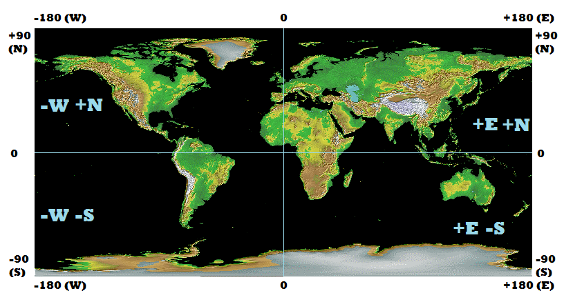
Navigation: latitude and longitude

The navigation grid using degrees minutes and seconds.  All points are referenced in terms of a point on the equator grid south of Greenwich England UK.  The direction suffixes N,S,E,W are in relation to this point.   from http://www.netwasgroup.us/services-2/grid-systems.html

The navigation grid using degrees minutes and seconds.
All points are referenced in terms of a point on the equator grid south of Greenwich England UK.
The direction suffixes N,S,E,W are in relation to this point.
from http://www.netwasgroup.us/services-2/grid-systems.html

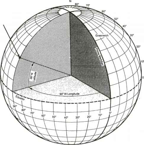
Latitude and longitude are the basis of navigation. The world is divided into a grid made up of imaginary parallel lines running from the north pole to the south pole called longitude and another set of imaginary lines parallel to the equator.

There is an imaginary point in the ocean on the equator directly south of Greenwich UK that is the reference point. The line of 0 longitude is called the prime meridian.

The angles in navigation relate to which angles latitude and longitude from the center of the earth to the surface in relation to the point 0º N and 0º E.

While the earth is not perfectly spherical, for most calculations it can be assumed to be.

Longitude is measured as how far east or west from this line of zero longitude.

longitude ranges from 180 W to 180E, -180 to +180

latitude is how for north or south from the equator

latitude ranges from 90 N to 90 S, +90 to -90

globe3t quadrants

all of these measurement are in degrees, where there are 360 degrees in a full circle.

degrees are also called degrees of an arc.

degrees can be subdivided into smaller parts for greater precision as the difference in distance between 35S and 36 S in 111.12 KM or 69 Miles.

degrees can be shown with a number following a decimal point called decimal degrees.

35.5 S

degrees can also be shown with minutes and seconds

35º 30′ 0″ S

In this case both are showing the same number.

To convert decimal degrees to degrees minutes and seconds:

take the decimal part and multiply by 60.

the whole part of this number is the minutes.

If there is a decimal part multiply by 60.

this number is the number of seconds.

there may be a decimal part you may chose to add this to your seconds or leave it off depending on the level of precision required.

remember 1 second of an arc is about 30 meters of about 101 feet so your decimal seconds is a subdivision of this amount in most cases not relevant and a level of precision neither necessary or possible to obtain with out complex instruments.

37.687605 N

0.687605 x 60 = 41.2563

41′

0.2563 x 60 = 15.378

15.378″

round to 2 decimal places

15.38″

37º 41′ 15.38″ N

To convert  degrees minutes and seconds to decimal degrees:

seconds divided by 3600

minutes divided by 60

add these two numbers and that will be the decimal part of the degrees

37º 41′ 15.38 N

15.38 /3600 = 0.004272

41/60 = 0.683333

0.004272 + 0.683333 = 0.687605

37.687605 N

To describe a specific position on the earth both longitude and latitude need to be specified.

Latitude (W/E) is specified first generally followed by Longitude (N/S)

Examples

Wichita Kansas USA

37º 41′ 15.38″ N   97º 20′ 11.44″ W

Sydney Australia

33º 51′ 23.74″ S   151º 12′ 54.29″ E

Scram Bag:The Needle


A needle, more useful and more difficult to make than you think.


Why is this so significant?

Yes it is a needle, it is used for sewing materials together.

The reason it is significant is because it is the oldest tool ever discovered that was not designed for killing or eating.

The first tool of construction. Men and women made clothes and other usefull items from this one giant leap in technology. It’s our first actual tool of construction. Everything before it was a tool for cutting, chopping, crushing or stabbing. Most previuos tools made things smaller, except this one which made things bigger. The first bone needles were found 6000BC older than recorded civilisation itself, You might assume it was a prerequisite for civilisation.

If you still think the needle is insignificant, try to make one that works well. you’ll find it’s very hard to do.

Using this knowledge imagine what would happen when civilsation as we know it collapses. The factories that currently produce needles would likely cease production at least for a time. Trade and transport networks will be disrupted perhaps permanently. The production of new clothes would likey halt. People would have worn and damaged clothes and be perhaps unable to replace them. New clothes may become rare and expensive to manufacture. Clothes are made of woven threads, theads will not be scarce. Needles possibly will be. Needles will likely become quite valuable. It’s possible may become a form of currency or at the very least a valuable item of barter. It’s clear that needles will be far more valuable than they are today.

Less obvious uses for a needle:

A needle can be bent and turned into a fishing hook.

Needles can be used as pins for sewing.

Needles can be used to clean out a wound or prick open a blister.

A magnetised needle floating on still water can be used as a compass.

Needle can be use to clear a small blockage in a metal filter or small gague pipes.

Stitching a wound closed.


Degrees minutes and seconds: human time and distance scale

It helps to have a tangible reference point when talking about degrees minutes and seconds.

If you plan journey using degrees minutes and seconds these are the real world parameters.

1 degree of an arc is = 60 Nautical miles = 69 Statute miles = 111.12 Kilometers

About 4-5 days walking at a typical speed on roads.

.

1 minute of an arc = 1 nautical mile = 6076 feet = 1.15 statute miles  = 1.852 kilometers

About 20 minutes of time walking at a typical speed on roads.

.

1 second of an arc is therefore 101.2666 feet  = 101 + 4/15  feet =  101 feet 3.2 inches = 33.755 yards  = 30.866 meters

20 to 30 seconds of time walking.

The size of a large house.

I did try to compare this distance to a football/soccer field. but even that is not standardized, if the most widely played sport has no standardized  field size, it explains why we are in the mess we are currently in.

Navigation: Distance in miles and nautical miles

For almost everything else the Metric system is the best system to use, it’s widely used in the world like the way English is understood.

The Metric system is extensively integrated into science and engineering.

However in Navigation based on extremely old standards (people have been making maps for as long as there have been kings) inherited from the Sumerian civilization.

When we talk about degrees° minutes’ and seconds”  they are commonly refereed to as degrees of an arc, minutes of an arc or seconds of an arc.

The basic idea is that 1 minute (of an arc) is 1 nautical mile.

1 minute of an arc = 1 nautical mile = 6076 feet = 1.15 statute miles  = 1.852 kilometers

1 second of an arc is therefore 101.2666 feet  = 101 + 4/15  feet =  101 feet 3.2 inches = 30.866 meters

Note the current standard American nautical mile is 6080.2 feet.

So because these standards are locked together an have huge historical legacy it worth learning them.

The idea that 1 minute of an arc is 1 nautical mile helps bring real world scale to something as abstract as 1/60 of 1 degree on a compass.

Calculation to show diameter of earth

Based on 180 degrees pole to pole : 1 minute of and arc  X 60  X 360 X nautical mile = circumference of earth

1* 60 * 360 = 21,600 nautical miles

circumference = π * D

circumference / π  =diameter of earth in nautical miles

21,600/ 3.14157 = 6875. 54 nautical miles

In kilometers:

6875.54 *1.852 km    =   12,733.5 km

accepted value, average earth diameter : 12,742 km

99.93% of the modern accepted value.

For example if you found a pirate treasure map, you can be sure its is distances are measured in nautical miles. Sadly even nautical miles had local variants due to local variants in what was a mile. Nautical mile are also 1% shorter at the poles as the earth is an oblate sphere ( a sphere with smaller diameter at the poles).

Navigation: Magnetic compass – Declination

The compass points north.

Being more specific the compass points to align itself the strongest magnetic field, which may or may not be grid north, usually not.

The north pole where all the lines of the map grid connect, sadly is not the magnet north pole, the same is true for the south pole.

The south pole is not even under Antarctica, it is not even covered in permanent ice, its just off the coast of Antarctica in the southern ocean.

With the right ship you could sail to the magnetic south pole.

So because of this you will need to add a correction factor (magnetic declination) based on exactly where you are on the earth (and years since map printed).

The world magnetic declination chart 2001

World Magnetic Declination map from http://www.phidgets.com/docs/Compass_Primer 4.3Mb

So what does this mean?

This will show you how much you compass be away from grid north when pointing to magnetic north and whether magnet north will be to the east or west of grid north.

Examples

in the area of former French Indochina Vietnam Cambodia, Laos and Thailand there is very little magnetic variation, less than 1 degree, so in that area grid north and magnetic north are almost identical.

magnetic declination in Former french Indochina, Laos, Cambodia ,Burma, Vietnam. Almost less than 1 degree, magnetic and grid north almost the same

For the USA and Canada the situation is much more complex

In the east the declination is to the west and in the west the declination is to the east.

Magnetic declination for the USA and Canada

The declination becomes extreme in the  Alaska and western Canada areas.

Magnetic declination Alaska and western Canada

Here the declination becomes quite significant, in Banks island the declination is around 40 degrees, being that the difference between East and North-East is 45 degrees, you would not want to get this wrong.

Australia and New Zealand

Magnetic declination Australia and New Zealand.

The declination problem is as extreme as the case for North America, the real issue especially for Australia is the magnetic anomalies.

You might recall that Australia is (in many places) simply made from iron ore, and iron is magnetic.

Interestingly in Australia declination changes most significantly as you move east and west, in New Zealand declination changes most when you move north and south. further more both countries have a major city close to the line of no  yearly declination variation ( Brisbane and Auckland)

Changes in magnetic declination yearly

Magnetic declination (and the location of the magnetic poles) changes with time.

The measurements of change are in the above charts as light blue lines and are in the units of minutes per year ( 1 minute being 1/60 of a degree).

Here is an animation of the slow changes in declination over a 400 year period from the USGS.

Earth Magnetic Field Declination from 1590 to 1990

Please note the most recent data on the animation is from 1990 as i write this its 22 years out of date so the charts from 2001 are more accurate.

Find your declination based on your IP address

http://magnetic-declination.com/

Manual calculation of declination changes

To do calculations on declination fist we must understand that the traditional navigation numerical system is
in base 60. Just like your wrist watch or clock, there are 60 minutes in an hour there are 60 minutes in an
degree. Change to declination due to shifts in the earths magnetic field are measured in minutes per year and just like declination itself, it is dependent on the position you are on the planet.

If you’re wondering where this numerical system came from, it came from Sumer, the first known civilization. While it seems like an awkward system at first, it is worth understanding, as it is completely embedded in geography, cartography navigation, astronomy and the measurement of time. Long after Sumerian was a dead language, scholars were studying Sumerian cuneiform to understand Sumerian knowledge of astronomy and cartography; all described in base 60: degrees, minutes and seconds.

Once a workable standard gets established, it gains considerable momentum.

http://implementimprovement.com/?p=1689

For simplicity of mathematics we will arbitrarily assign east to positive declination and west to negative declination.  As north is considered to be 0 or 360 degrees on a compass this will make sence, 15 degrees east is +15 degrees 20 degrees west is 340 degrees (360 -20). Just like on a clock at midday it is 12 and the next hour is 1 and the previous hour is 11.

Math with degrees minutes and seconds
1 degree = 60 minutes = 3600 seconds
with notation
1°  = 60′ = 3600″

Example 1

Melbourne, Australia

In 2001 declination was 11.5 E; which is 11 degrees 30 minutes E.
Change in declination was 0.75 minutes per year E; which is 0 minutes 45 seconds.
Time passed since map drawn was 11 years

Total declination change 11 x 0’45″E

This is the same as saying how many minutes have passes in 11 45 second time periods.

11 x 45 seconds = 495 seconds

In minutes and seconds?

495 / 60  = 8.25   = 8 minutes 15 seconds ( 0.25 of a minute is a quarter of a minute, which is 15 seconds)

8′ 15″ E

Convert all E to + and all W to –

+11° 30′ + 0° 8′ 15″

+11° 38′ 15″

Convert + to E and – to W
11° 38′ 15″ E

Example 2

Banks Island, Canada

I selected a location where the declination line 39°E crossed the declination change 45′ W as a more extreme example
Time passed since map drawn was 11 years.

Total declination change 11 x 45′ W = 495′
How many degrees and minutes is this?
495/60 = degrees of change = 8.25 which is 8 15′ W
Interestingly the math was identical as before but the magnitude is 60 times larger.

Converting E to + and W to –

39° 0′ 8° 15′ = 30° 45′

Declination calculation in Degrees Minutes Seconds example

A hand written calculation of the example. please note the carry of the 6, which is really carry the 60 minutes

39° 00′ = 38° 60′

Because 1 degree = 60 minutes

+30° 45′
Convert + to E and – to W
30° 45′ E

So now that I have explained all of this and not even shown a picture of a compass you may be wondering about my logic.

Navigation by compass is not a simple affair, well not as simple as it appears once declination and declination change is taken into account.

The real importance of understanding declination becomes apparent once you are doing one or more of the following:

Traveling long distance.

Traveling on featureless terrain, desert, tundra, steeps, prairie, ocean.

Attempting to triangulate your position from landmarks.

Making decisions based on precise measurement of where north or south is, such as a sundial orientation or solar panel placement.

Using a very old map.

In a location with large annual declination change ( Canada, eh ).

Using a sextant.

Learn the parameters of your tools.

There is nothing worse than having too much faith in a tool you really don’t understand the subtleties of.

I will add that in trying to explain all of this, which was 24 hours of research and writing, I learned a lot.

I hope you have learned a lot too. You’ll never think about North the same way again.

Even so unless I’m on the ocean, I say the map is far more important than the compass.
Navigation: Astronomical Southern Hemisphere South

I was reading a gear list someone posted today and I thought it looked quite good, it even included a map and compass.

Then I realized while I have a compass, I don’t consider it essential.

I consider the map (especially if it is topographical ) essential but not the compass.
I can find my direction at night using the stars and during the day with the sun.

South at night with the stars:

For everyone in the northern hemisphere this is possibly redundant but explains an important point.

In the northern hemisphere finding the north pole star Polaris is quite simple, find the little dipper and follow the handle to Polaris that is always grid north.

This works because the pole star is quite bright and the little dipper is quite distinctive.

In the southern hemisphere not only is Polaris not visible, neither is the little dipper.

We don’t have a pole star but we have a bright distinctive crucifix pattern (Crux) called the southern cross which also has a pair of very bright star close to it Alpha and beta Centuri called ‘the pointers’.

Alpha Centuri is the brightest star in the southern hemisphere is its quite distinctive and is almost always visible.

A line imagined between the pointers if extended will intersect with the top star of the cross.

The long arm of the cross always point to the pole star , may be in any orientation in the sky as it rotates around the pole.

Once the cross is found you simple measure the major axis the longest line in the cross and extend this line out in the direction of the major axis 3.1 times and it will be intersecting with the pole star.

The from that point a line that is perpendicular to the horizon will be south.

The pole star may be visible or not depending on how good star viewing is on the night.

The point is this method help you find something you can’t see ( a non existent southern pole star) to find another thing you cant see ( grid south ) in the dark when you can’t see much anyway.

Quality knowledge allows you to do near impossible things.

One again proof of the idiom One picture, One thousand words.

How to find south using the stars in the southern hemisphere.

There is some debate as to whether  you should use 3 axes or 4 or 4.5, the reality is you will most likely be measuring with fingers spans and the width of your arm so its not that precise.  regardless if you are traveling at night you should be more worried about whats on the ground rather than the exact direction or south to the nearest degree.  If you used a compass you would have to convert magnetic south north to grid north and  you would be hoping for no nearby magnetic anomalies.

Update: having further examined this issue the correct number of axes to use is 3.53, but being that you will most likely be measuring with fingers between 3 and 4 is good enough. I will try to get an estimate of how large the cross axis will appear compared to an out stretched finger. From memory it’s about the width of two fingers.