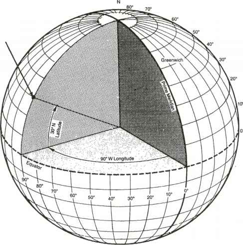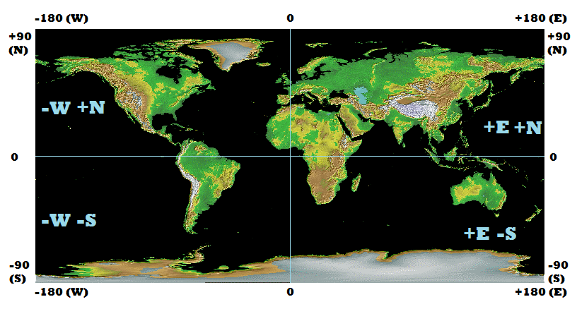
The navigation grid using degrees minutes and seconds.
All points are referenced in terms of a point on the equator grid south of Greenwich England UK.
The direction suffixes N,S,E,W are in relation to this point.
from http://www.netwasgroup.us/services-2/grid-systems.html
Latitude and longitude are the basis of navigation. The world is divided into a grid made up of imaginary parallel lines running from the north pole to the south pole called longitude and another set of imaginary lines parallel to the equator.
There is an imaginary point in the ocean on the equator directly south of Greenwich UK that is the reference point. The line of 0 longitude is called the prime meridian.
The angles in navigation relate to which angles latitude and longitude from the center of the earth to the surface in relation to the point 0º N and 0º E.
While the earth is not perfectly spherical, for most calculations it can be assumed to be.
Longitude is measured as how far east or west from this line of zero longitude.
longitude ranges from 180 W to 180E, -180 to +180
latitude is how for north or south from the equator
latitude ranges from 90 N to 90 S, +90 to -90
all of these measurement are in degrees, where there are 360 degrees in a full circle.
degrees are also called degrees of an arc.
degrees can be subdivided into smaller parts for greater precision as the difference in distance between 35S and 36 S in 111.12 KM or 69 Miles.
degrees can be shown with a number following a decimal point called decimal degrees.
35.5 S
degrees can also be shown with minutes and seconds
35º 30′ 0″ S
In this case both are showing the same number.
To convert decimal degrees to degrees minutes and seconds:
take the decimal part and multiply by 60.
the whole part of this number is the minutes.
If there is a decimal part multiply by 60.
this number is the number of seconds.
there may be a decimal part you may chose to add this to your seconds or leave it off depending on the level of precision required.
remember 1 second of an arc is about 30 meters of about 101 feet so your decimal seconds is a subdivision of this amount in most cases not relevant and a level of precision neither necessary or possible to obtain with out complex instruments.
37.687605 N
0.687605 x 60 = 41.2563
41′
0.2563 x 60 = 15.378
15.378″
round to 2 decimal places
15.38″
37º 41′ 15.38″ N
To convert degrees minutes and seconds to decimal degrees:
seconds divided by 3600
minutes divided by 60
add these two numbers and that will be the decimal part of the degrees
37º 41′ 15.38 N
15.38 /3600 = 0.004272
41/60 = 0.683333
0.004272 + 0.683333 = 0.687605
37.687605 N
To describe a specific position on the earth both longitude and latitude need to be specified.
Latitude (W/E) is specified first generally followed by Longitude (N/S)
Examples
Wichita Kansas USA
37º 41′ 15.38″ N 97º 20′ 11.44″ W
Sydney Australia
33º 51′ 23.74″ S 151º 12′ 54.29″ E

You must be logged in to post a comment.